Training
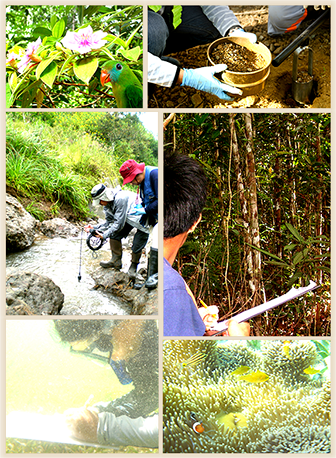
Environmental Management
We provide awareness and skills training for environmental and social management at all levels. Our training programs are formulated after a careful and thorough evaluation of the client’s capabilities, situation, and needs.
We train the participants to focus on the impact, i.e., the difference between what would happen on the key environmental conditions and the socio-economic consequences at each project phase and what would happen if the project were not undertaken. The impact may be positive or adverse and direct or indirect. We familiarize the trainees with best-practice sampling, laboratory analyses, and specialist studies appropriate to the specific impact.
Impact mitigation planning follows impact assessment. Using actual cases, the trainees learn to apply the mitigation hierarchy as well as the design and performance standards. By iteration using cost-benefit analysis, the best mitigation strategy and mix of measures are selected. Climate considerations are covered for climate-vulnerable projects.
The training concludes with linking the mitigation plan to project monitoring and management systems.
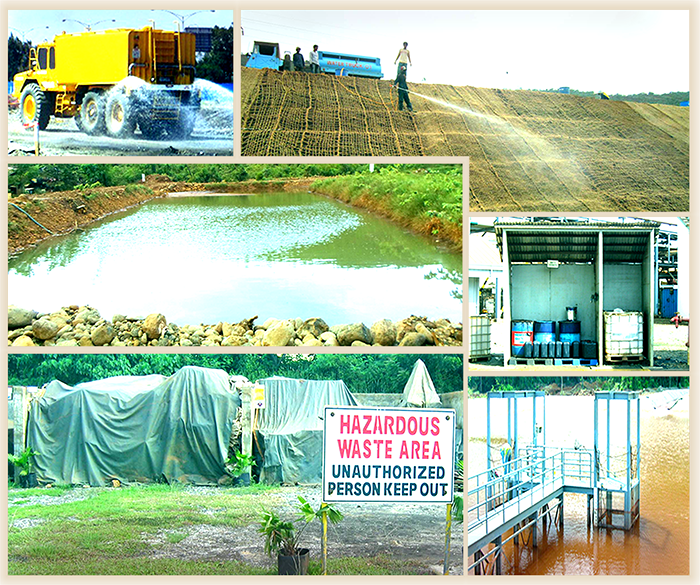
Environmental Monitoring
Our training on Environmental Monitoring goes beyond the usual sample collection, comparison of sampling results with regulatory standards, and reporting.
First, we lay down the priors: airshed or watershed assessment, site conceptual modeling, field assessment design, and quality assurance (QA) and quality control (QC) plan. The assessment and modeling ensure the relevance and efficiency of the field assessment design. The design defines the parameters for monitoring, analytical method, sampling station locations, number of replicates, and sampling frequency. In the design, we stress statistical power and go for the Before-After-Control-Impact (BACI) or BACI Paired Series design. The QA/QC plan, which consists of management and technical procedures and activities, ensures measurements that satisfy the required quality.
Our data processing and analysis – the basis of decision-making – are statistical-based. We familiarize the trainees with the diverse types of monitoring: detection, assessment, and corrective action monitoring. We then expound on the different statistical processing and analysis for each.
Community Development
Depending on client’s needs and the circumstances of the project, we run generalist and specialist training courses on community development. Our courses start off with IAIA’s international principles on social impact assessment to which we adhere.
Our full course follows six sequential steps: know the community and the environment; know how the project impacts the community and environment; develop strategic comprehensive plans with measurable indicators including an organizational plan, stakeholder engagement plan, and communications plan; implement the plans, monitor and do adaptive management; and document and report accomplishments.
Our specialist courses focus on one or a select few of the six steps. The course may also cover specific subsets such as project planning, looking for key partners and forming successful partnerships, developing indicators and a data management system, or infusing sustainability elements into the community development plan.
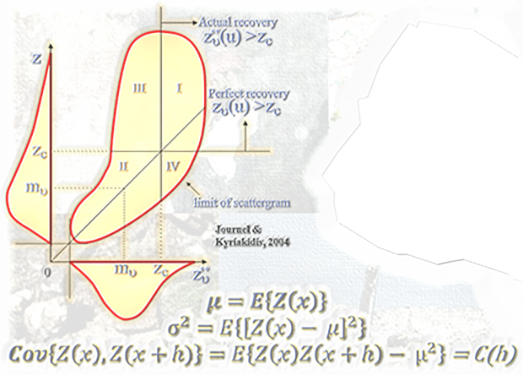
Geostatistics
Our courses are designed for the exploration geologists, mining engineers, and environmental scientists and engineers dealing with spatially distributed phenomena such as ore grade, contaminant, species occurrence or population, etc.
In our starter course, we first train the participants with the concepts, methods, and measures of classical descriptive statistics, exploratory data analysis, statistical inference, and probability theory. Their limitations in dealing with spatial phenomena are highlighted. Geostatistics is then introduced with its goals, framework, toolset, applications, and limitations. The learnings are applied to real-world data sets.
Other more involved trainings are available: kriging and co-kriging for point or block estimation; assessment of local uncertainty through the multigaussian and indicator approach; and geostatistical simulation and applications in the assessment of mineral reserves, environmental contamination, ore grade dilution and grade control, and variability of mill feed grade.